Commercial Property Aerial Condition Screening
This sample report demonstrates the full scope of a SION Property Intelligence engagement — from aerial data collection through a phased remediation framework. All data is real. The site is a Memphis-area commercial property. No client name or address is displayed.
This report was produced using real drone flight data collected over a Memphis-area commercial property. It is published as a sample deliverable to demonstrate the SION Property Intelligence process. It does not represent a client engagement. All observations are based solely on aerial orthomosaic imagery. No structural, engineering, or licensed inspection conclusions are made.
The complete 14-page PDF includes the executive summary, property intelligence dashboard, annotated orthomosaics, zone-by-zone findings, roof callout documentation, and phased remediation framework.
Full-Site Orthomosaic
The georeferenced orthomosaic provides a top-down, scaled view of the entire ~4.2-acre site — building footprint, parking field, drive lanes, landscaping, and perimeter. Approximately 333 nadir images were processed to produce this orthomosaic.
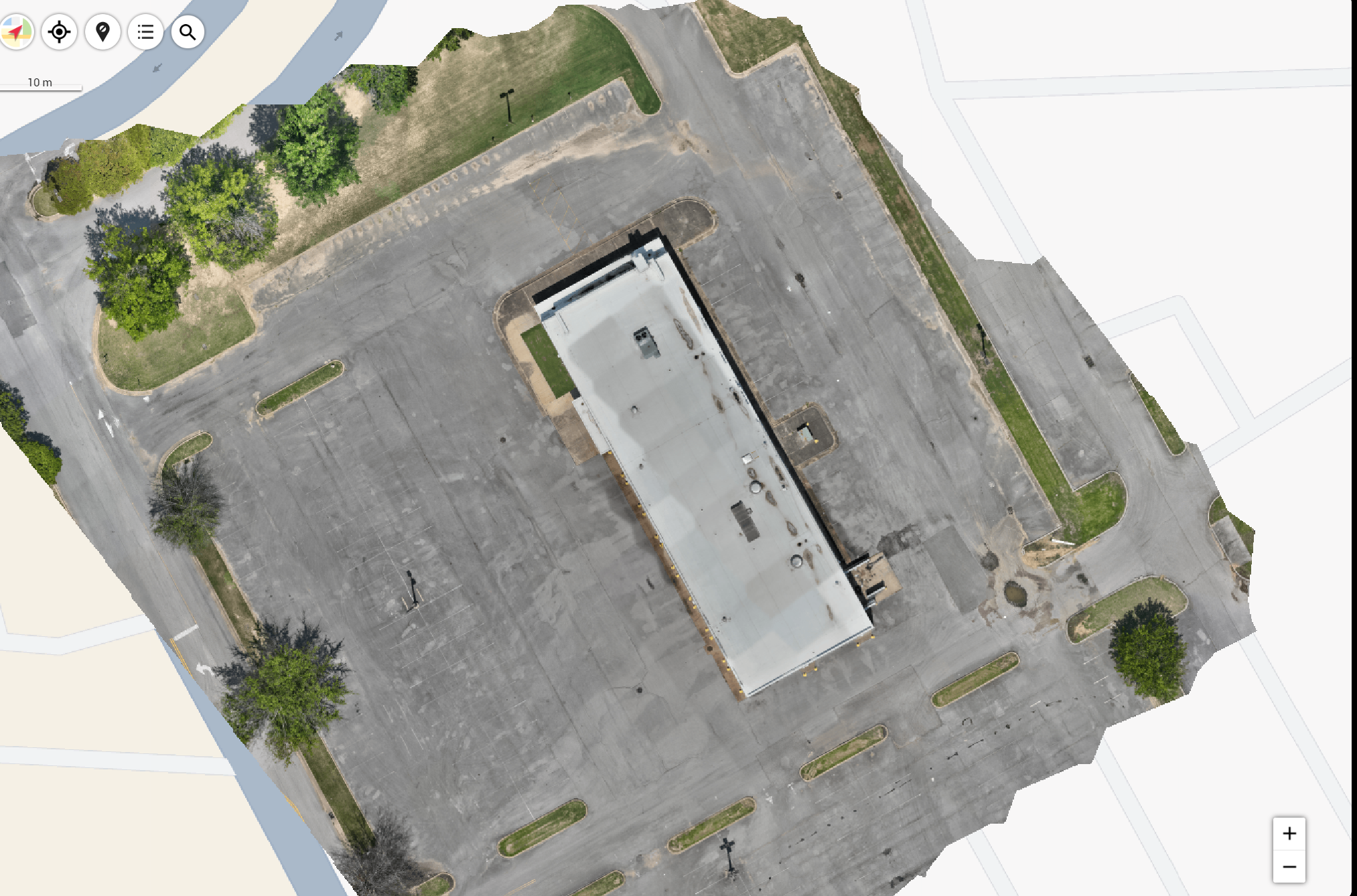
Figure 1 — Full-site orthomosaic. Memphis-area commercial property, July 2026. ~4.2-acre footprint.
System-Level Condition Scores
Each major property system is scored using the SION Property Condition Scoring (SPCS) methodology. Scores are based on aerial observation only. Systems requiring licensed inspection are noted as NOT SCORED.
| System | SPCS Score | Rating |
|---|---|---|
| Pavement — Parking Field | 41 | POOR |
| Pavement — Drive Lanes | 38 | POOR |
| Striping / Line Marking | 25 | SERIOUS |
| Drainage System | 52 | POOR |
| Roof — Membrane | 82 | GOOD |
| Curbs & Wheel Stops | 74 | FAIR |
| Sidewalks / Pedestrian Areas | 90 | EXCELLENT |
Scores reflect aerial observation only. ADA compliance, site lighting, and HVAC/penetration systems require licensed professional review and are not scored from aerial imagery.
Pavement Condition Map — Zones 1–6
The annotated orthomosaic identifies six primary observation zones across the parking field and drive lanes. Each callout corresponds to a visible distress condition documented in the aerial imagery. Severity indicators are based on aerial observation and should be confirmed by a qualified paving contractor before mobilization.
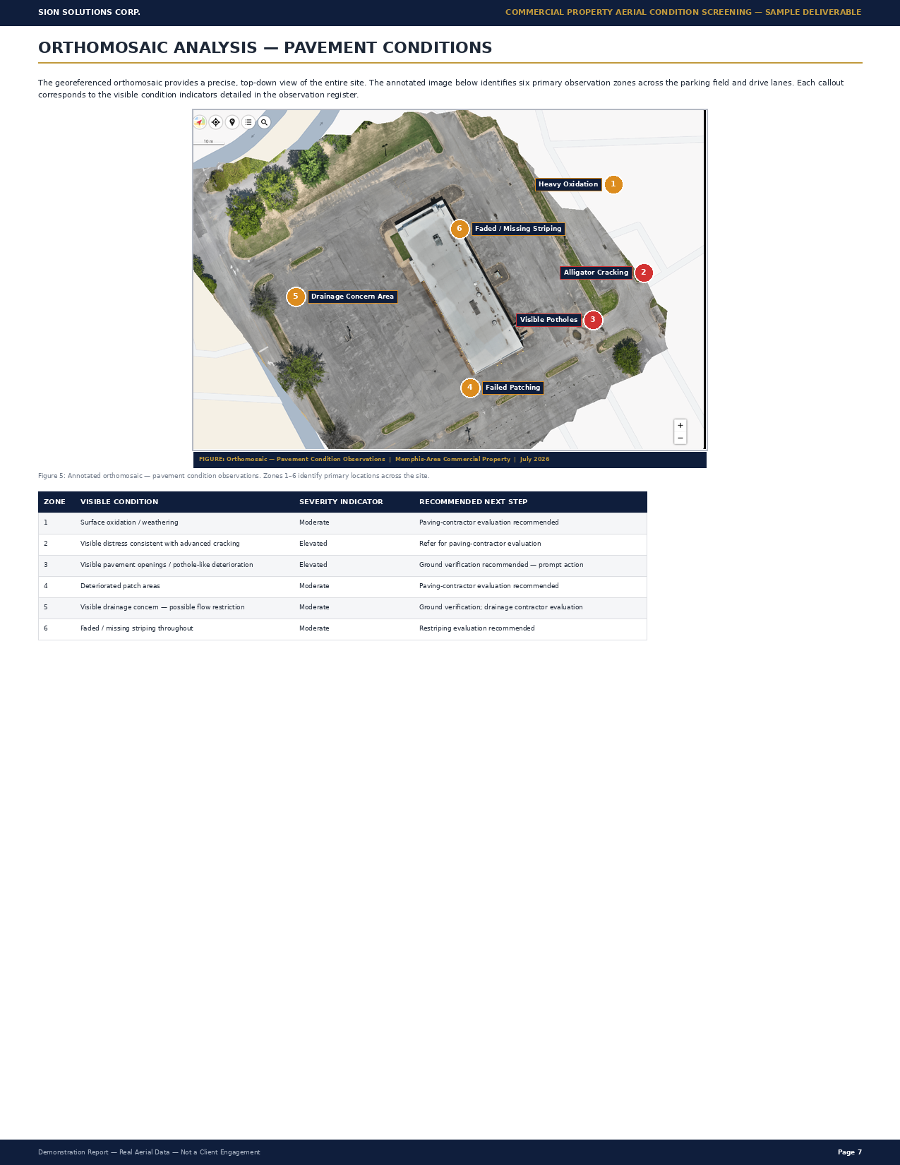
Figure 2 — Annotated orthomosaic. Six primary pavement distress zones mapped across the ~4.2-acre site.
| Zone | Visible Condition | Severity Indicator |
|---|---|---|
| 1 | Surface Oxidation | MODERATE |
| 2 | Advanced Cracking | ELEVATED |
| 3 | Visible Pavement Openings | ELEVATED |
| 4 | Deteriorated Patching | MODERATE |
| 5 | Drainage Concern Area | MODERATE |
| 6 | Faded / Missing Striping | MODERATE |
Severity indicators are based on aerial orthomosaic observation only. Engage a qualified paving contractor for close-range evaluation before scope or budget development.
Roof Condition Documentation — Callouts A–F
The close-range roof orthomosaic provides a top-down view of the building roof at sufficient resolution to identify visible membrane conditions, drainage indicators, HVAC equipment placement, and penetration locations.
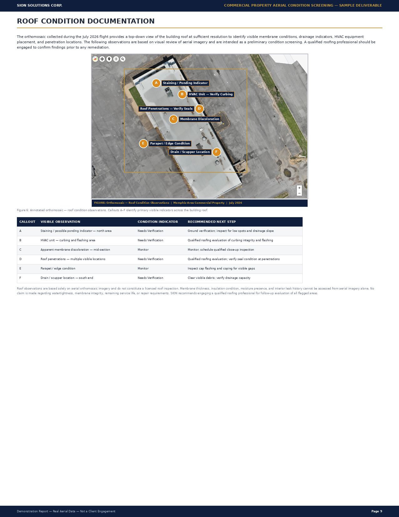
Figure 3 — Annotated roof orthomosaic. Six primary observations across the building roof membrane.
| Ref | Visible Observation | Status |
|---|---|---|
| A | Staining / Ponding Indicator | NEEDS VERIFICATION |
| B | HVAC Unit — Verify Curbing | NEEDS VERIFICATION |
| C | Membrane Discoloration | MONITOR |
| D | Roof Penetrations — Verify Seals | NEEDS VERIFICATION |
| E | Parapet / Edge Condition | MONITOR |
| F | Drain / Scupper Location | NEEDS VERIFICATION |
Roof observations are based solely on aerial orthomosaic imagery and do not constitute a licensed roof inspection. Membrane thickness, insulation condition, interior leak history, and watertightness cannot be assessed from aerial imagery. SION recommends engaging a licensed roofing contractor for close-range evaluation of all flagged callouts before any remediation scope is developed.
Phased Remediation Framework
Based on the aerial condition assessment, SION developed a phased remediation framework addressing site deficiencies in priority order. All scope and budget development requires contractor confirmation. These phases are a planning framework, not a bid or cost estimate.
Address visible pavement openings and drainage concern areas. Engage paving contractor for close-range evaluation of Zones 2, 3, and 5 before mobilization.
Contractor-evaluated full-depth patching of advanced cracking zones. Overlay on deteriorated drive lanes and parking field sections as confirmed by contractor assessment.
Crack fill and seal coat application across moderate-condition zones. Full-site restriping including all parking stalls, drive lanes, fire lanes, and ADA-compliant markings.
Engage licensed roofing contractor to evaluate all six aerial callouts (A–F). Assess drainage inlet locations identified in Zone 5. Regrade low spots contributing to standing water.
What This Assessment Demonstrates
Ready to assess your property?
SION Solutions serves commercial property owners, facility managers, and real estate professionals across Memphis, Shelby County, North Mississippi, and Eastern Arkansas.