
Commercial parking lots rarely fail overnight. They deteriorate gradually — through water intrusion, UV exposure, heavy traffic loading, and poor drainage. The challenge is not that these problems exist. The challenge is that most organizations do not detect or document them until repair costs have already escalated significantly.
Every pothole started as a crack someone ignored. The question is: are you documenting those clues — or waiting until they become expensive?
The Mission
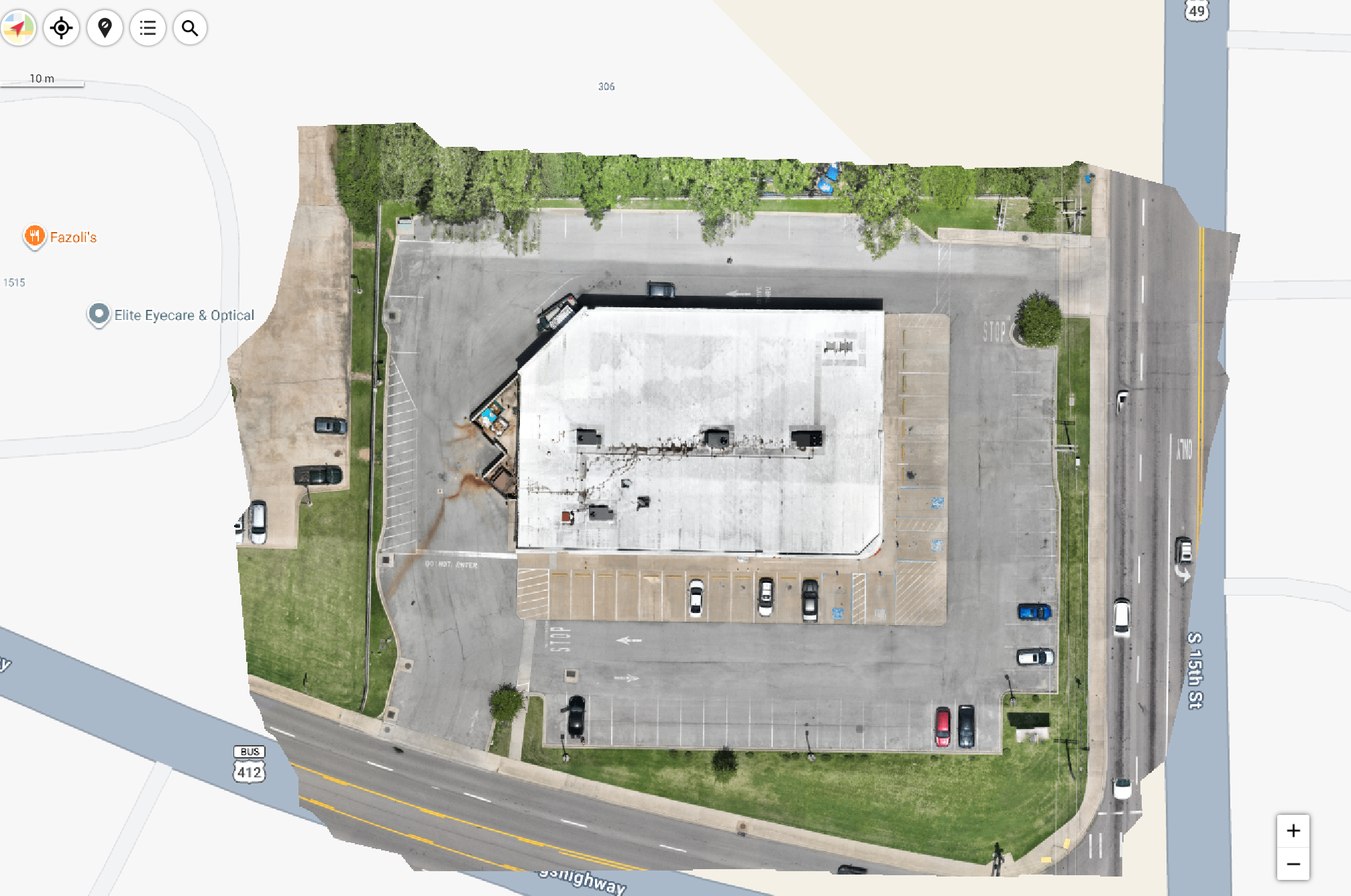
SION Solutions recently completed an aerial pavement documentation mission for a commercial property in Paragould, Arkansas. The objective was not simply to capture aerial imagery — it was to create actionable information that supports smarter maintenance decisions.
Using a high-resolution drone platform, we generated an orthomosaic of the entire site — a geometrically corrected, measurable aerial image that provides an accurate, scaled record of the property. Unlike a standard aerial photo, an orthomosaic can be measured, referenced, and compared against future inspections.
What the Data Reveals
From a single dataset, facility managers and property owners can evaluate the entire pavement system at once — something that is simply not possible from ground level. The orthomosaic provides visibility into:
- Overall pavement condition across the entire lot
- Early signs of cracking and surface deterioration
- Drainage patterns and areas where water may accelerate pavement failure
- ADA parking layouts and accessibility considerations
- Traffic flow and high-wear areas
- Existing site conditions for future maintenance planning
Perhaps the biggest misconception about pavement maintenance is that age determines replacement. It does not. Condition determines replacement. A 15-year-old lot with proper drainage and documented maintenance history may outlast a 7-year-old lot with undetected water intrusion and deferred repairs.
The Business Case for Aerial Documentation
The cost of a drone pavement inspection is a fraction of the cost of one emergency asphalt repair. More importantly, it changes the nature of the decision. Instead of reacting to visible damage, property owners and facility managers can plan proactively — prioritizing repairs, budgeting accurately, and communicating clearly with contractors.
- Better capital planning — know what needs attention before it becomes urgent
- Improved maintenance prioritization — address high-risk areas first
- Reduced emergency repair risk — catch water intrusion before it undermines the base
- Better contractor communication — share the same visual data with every bidder
- Historical documentation — a baseline for every future inspection
- Improved budgeting — replace reactive spending with planned expenditure
- Reduced site inspection time — one flight covers what would take hours on foot
What the Client Received
At the conclusion of this mission, the client received a complete documentation package:
- High-resolution orthomosaic of the entire site
- Aerial overview imagery
- Existing condition documentation
- Maintenance planning support data
- Visual asset inventory
- Digital archive for future reference
- Future comparison baseline for subsequent inspections
Three Lessons From This Project
Every mission teaches something. Here is what this one reinforced:
- Small pavement issues are significantly easier to identify when viewed as an entire system rather than individual problem spots.
- High-resolution aerial documentation provides a baseline that makes every future inspection more valuable — the comparison is where the real intelligence lives.
- Preventive maintenance decisions become easier when all stakeholders share the same visual data. Contractors bid more accurately. Owners approve budgets more confidently.
The goal is not to fly a drone. The goal is to help organizations make better decisions using better information. Infrastructure rarely fails without warning — it gives clues long before it demands a major repair budget.
Is Your Property Due for an Assessment?
If you manage a commercial property, retail center, parking facility, or municipal site in the Mid-South, an aerial pavement assessment is a conversation worth having. SION Solutions offers a free site assessment consultation — no obligation, just a clear picture of what aerial documentation can reveal for your specific property.
SION Solutions | Actionable Aerial Intelligence FAA Part 107 Operations · Veteran-Owned · Serving the Mid-South Founded by Ivory Cooper, former FAA Memphis District Manager
Not sure if aerial documentation is right for your property? Let us take a look. SION Solutions offers a free consultation for commercial property owners, facility managers, and contractors in the Mid-South. No obligation — just a clear picture of what we can reveal.
Call 901-290-8372