
Construction disputes cost the U.S. industry an estimated $15 billion per year in legal fees, arbitration, and project delays. The overwhelming majority of those disputes share the same root cause: no one documented what the site actually looked like at the moment the disagreement started. A subcontractor says the work was complete. The GC says it was not. The owner says the scope changed. Everyone has emails. No one has a dated, georeferenced visual record of the site on the day in question.
That is the problem aerial progress documentation solves — not by preventing disagreements, but by making them impossible to sustain. When every phase of a project is documented from the air on a consistent schedule, the record speaks for itself. What was on site. What was installed. What was graded. What was backfilled. All of it, dated and georeferenced, accessible from any device.
The Documentation Gap That Creates Disputes
Most construction projects are documented at the ground level — photos taken by a superintendent walking the site, progress reports written by the project manager, RFIs and submittals filed in a project management system. That documentation is valuable, but it has a fundamental limitation: it captures what someone decided to photograph, not a complete record of the site at a specific point in time.
Aerial documentation changes the equation. A drone flight over an active construction site captures the entire project area in a single pass — every stockpile, every trench, every structure, every piece of equipment. The resulting orthomosaic is a measurable, annotatable map of the site on that specific date. It is not a selection of what someone thought was important. It is everything.
The most expensive documentation is the documentation you did not take. A $400 drone flight at the right moment can prevent a $40,000 dispute.
What Gets Documented — and Why It Matters
The value of aerial progress documentation is not just in the images — it is in the combination of spatial accuracy, timestamp, and completeness that no ground-level photo can replicate. A dated orthomosaic of a site before backfill establishes exactly what was installed and where. A dated orthomosaic after a grading dispute establishes the actual cut and fill volumes. A dated orthomosaic at substantial completion establishes the as-built condition of every surface-visible element.
- Site condition at mobilization — establishes pre-construction baseline for existing conditions claims
- Earthwork and grading progress — measurable cut/fill volumes at each documentation interval
- Underground utility installation — aerial record before backfill of pipe, conduit, and drainage runs
- Structural progress — framing, masonry, and concrete placement documented at each phase
- Subcontractor work areas — establishes who was working where and when
- Substantial completion condition — as-built aerial record of all surface-visible elements
The Three Disputes Aerial Documentation Prevents
Scope disputes are the most common. A subcontractor claims work was performed; the GC or owner disputes it. Without a dated visual record, the argument becomes a contest of credibility. With a dated orthomosaic showing the site condition before and after the claimed work, the record is unambiguous.
Existing conditions disputes arise when damage or defects are discovered and the question becomes whether they were pre-existing or caused by the contractor. A pre-construction aerial survey establishes the site condition at mobilization with a level of completeness that a walkthrough inspection cannot match.
Change order disputes often come down to whether the scope actually changed or whether the contractor underestimated the original scope. Aerial documentation of site conditions at the time a change order is issued — showing the actual field conditions that drove the change — provides the context that written change order documentation alone cannot.
How Memphis Contractors Are Using It
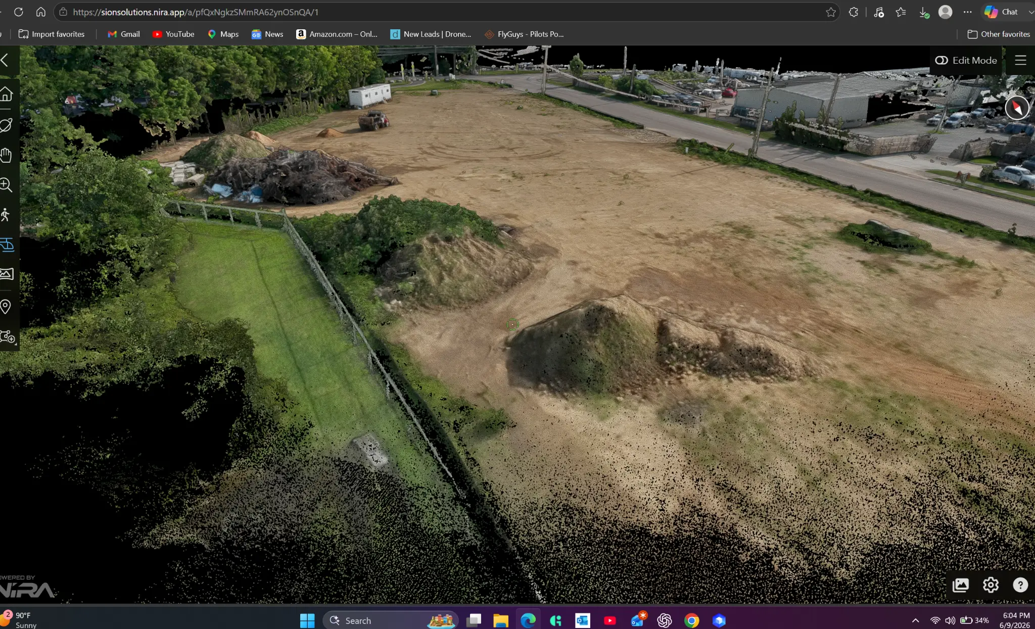
The image above is from an active project in the Memphis area — a real SION Solutions engagement, documented using the Nira platform. The 3D point cloud shows the site in detail: stockpiles, graded areas, drainage features, and site boundaries, all captured in a single flight and accessible from any device via a shareable link. The project team can measure distances, calculate volumes, and annotate areas of concern directly in the browser — no specialized software required.
For the superintendent, the value is immediate: a complete site record at each documentation interval that can be shared with the owner, the design team, and the subcontractors without printing a single page. For the project manager, it is a risk management tool — a dated, georeferenced record that makes scope disputes difficult to sustain and change order justifications straightforward to document. For the owner, it is accountability — a complete visual record of how their investment progressed from mobilization to completion.
One shared link. The entire site. Every phase. Accessible by every stakeholder from any device. That is what aerial progress documentation delivers.
The Recommended Documentation Schedule
- Pre-construction survey — before mobilization, establishes existing conditions baseline
- Earthwork and underground phases — weekly or bi-weekly during active grading and utility installation
- Structural phases — at each major milestone (slab, framing, enclosure)
- Substantial completion — full site documentation before owner acceptance
- Post-construction — 30 and 90 days after completion for warranty baseline
What the Deliverable Includes
- High-resolution orthomosaic — measurable, annotatable aerial map of the entire project area
- 3D point cloud model — accessible via shareable Nira link from any device, no software required
- Imagery library — 100+ images from multiple angles and elevations
- Volume calculations — cut/fill estimates for earthwork phases
- Dated digital archive — permanent, timestamped record of site condition at each interval
- Shareable project link — accessible by owner, design team, subcontractors, and legal counsel
Schedule Your Pre-Construction Survey
The best time to start aerial documentation is before the first shovel enters the ground. A pre-construction survey costs less than a single hour of dispute resolution and creates the baseline record that protects every party on the project. SION Solutions serves contractors, owners, and project managers across the Mid-South — Memphis, Shelby County, and surrounding areas in Tennessee, Mississippi, and Arkansas.
SION Solutions | Actionable Aerial Intelligence FAA Part 107 Operations · Veteran-Owned · Serving the Mid-South Founded by Ivory Cooper, former FAA Memphis District Manager
Not sure if aerial documentation is right for your property? Let us take a look. SION Solutions offers a free consultation for commercial property owners, facility managers, and contractors in the Mid-South. No obligation — just a clear picture of what we can reveal.
Call 901-290-8372